![](/images/other/stat-length.png)
![Excursión Marcha nórdica Le Bonhomme - Autour de le Bonhomme - Photo](https://media.geolcdn.com/t/1900/400/ext.pjpeg?maxdim=2&url=https%3A%2F%2Fstatic1.geolcdn.com%2Fsiteimages%2Fupload%2Ffiles%2F1545311037marcheuse_200dpi.jpg)
Autour de le Bonhomme
scaillet
Usuario
![Longitud](/images/other/stat-length.png)
Longitud
21 km
![Altitud máxima](https://static1.geolcdn.com/siteimages/upload/files/1508320355ic_sort_altitude_max_24dp.png)
Altitud máxima
1108 m
![Desnivel positivo](https://static1.geolcdn.com/siteimages/upload/files/1508320355ic_sort_den_pos_24dp.png)
Desnivel positivo
890 m
![Km-Effort](/images/other/stat-length.png)
Km-Effort
32 km
![Altitud mínima](https://static1.geolcdn.com/siteimages/upload/files/1508320355ic_sort_altitude_min_24dp.png)
Altitud mínima
633 m
![Desnivel negativo](https://static1.geolcdn.com/siteimages/upload/files/1508320355ic_sort_den_neg_24dp.png)
Desnivel negativo
891 m
![Boucle](https://static1.geolcdn.com/siteimages/upload/files/16400158638029165_repeat_loop_refresh_sync_direction_icon.png)
Boucle
Sí
Fecha de creación :
2022-10-07 14:25:40.17
Última modificación :
2022-10-07 14:28:46.994
![Marcha nórdica](https://static1.geolcdn.com/sitytour/trail-icons/102.png)
4h00
Dificultad : Medio
![Escanee este código QR para abrir la excursión en la aplicación SityTrail](https://capi.geolives.com/qq0zvz2zws4bq2lad0pu/sitytour/trails/3415893/qr.png?size=200)
Aplicación GPS de excursión GRATIS
A propósito
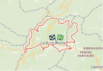
Ruta Marcha nórdica de 21 km a descubrir en Gran Este, Alto Rin, Le Bonhomme. Esta ruta ha sido propuesta por scaillet.
Descripción
Le Bonhomme, la chapelle Sainte-Claire, le col du Bonhomme, le col des Bagenelles, le Haut Pré, la Haute Pierre, le Grand Trait, Graine Berry et Le Bonhomme.
Localización
País:
France
Región :
Gran Este
Departamento/provincia :
Alto Rin
Municipio :
Le Bonhomme
Localidad:
Unknown
Salida:(Dec)
Salida:(UTM)
360049 ; 5337121 (32U) N.
Comentarios
Excursiones cerca
![Excursión Senderismo Le Bonhomme - Tête des faux . - Photo](https://media.geolcdn.com/t/375/260/84fec98d-7f8b-4bf8-a434-52c0363ad440.jpg&format=jpg&maxdim=2)
![Senderismo Senderismo](https://static1.geolcdn.com/sitytour/trail-icons/101.png)
Tête des faux .
Senderismo
Medio
(1)
Le Bonhomme,
Gran Este,
Alto Rin,
France
![](/images/other/stat-length.png)
11,9 km | 16,6 km-effort
3h 46min
![](https://static1.geolcdn.com/siteimages/upload/files/16400158638029165_repeat_loop_refresh_sync_direction_icon.png)
Sí
![Excursión Senderismo Lapoutroie - 2012-06-16 Marche aux Alisiers Orbey - Photo](https://media.geolcdn.com/t/375/260/ext.jpg?maxdim=2&url=https%3A%2F%2Fstatic1.geolcdn.com%2Fsiteimages%2Fupload%2Ffiles%2F1553511878bg_sport_marche.png)
![Senderismo Senderismo](https://static1.geolcdn.com/sitytour/trail-icons/101.png)
2012-06-16 Marche aux Alisiers Orbey
Senderismo
Fácil
(2)
Lapoutroie,
Gran Este,
Alto Rin,
France
![](/images/other/stat-length.png)
11,1 km | 16,6 km-effort
2h 49min
![](https://static1.geolcdn.com/siteimages/upload/files/16400158638029165_repeat_loop_refresh_sync_direction_icon.png)
Sí
![Excursión Bici de montaña Orbey - Lac Blanc - Têtes des Faux - Photo](https://media.geolcdn.com/t/375/260/ext.jpg?maxdim=2&url=https%3A%2F%2Fservices.sitytrail.com%2FGeolivesWS%2FDownloadMedia.ashx%3FTrailID%3D101197%26Media%3D684_1.jpg)
![Bici de montaña Bici de montaña](https://static1.geolcdn.com/sitytour/trail-icons/202.png)
Lac Blanc - Têtes des Faux
Bici de montaña
Medio
(1)
Orbey,
Gran Este,
Alto Rin,
France
![](/images/other/stat-length.png)
15,3 km | 21 km-effort
1h 0min
![](https://static1.geolcdn.com/siteimages/upload/files/16400158638029165_repeat_loop_refresh_sync_direction_icon.png)
Sí
![Excursión Senderismo Le Bonhomme - Le Bonhomme - Circuit du village - Photo](https://media.geolcdn.com/t/375/260/ext.jpg?maxdim=2&url=https%3A%2F%2Fstatic1.geolcdn.com%2Fsiteimages%2Fupload%2Ffiles%2F1553511878bg_sport_marche.png)
![Senderismo Senderismo](https://static1.geolcdn.com/sitytour/trail-icons/101.png)
Le Bonhomme - Circuit du village
Senderismo
Fácil
(1)
Le Bonhomme,
Gran Este,
Alto Rin,
France
![](/images/other/stat-length.png)
3 km | 5,3 km-effort
1h 30min
![](https://static1.geolcdn.com/siteimages/upload/files/16400158638029165_repeat_loop_refresh_sync_direction_icon.png)
Sí
![Excursión Senderismo Sainte-Marie-aux-Mines - 2021-02-14 Marche Bagenelles Brezouard Fuste de Etoile - Photo](https://media.geolcdn.com/t/375/260/79d211e6-ae5a-4d3f-8163-d2103469db38.jpg&format=jpg&maxdim=2)
![Senderismo Senderismo](https://static1.geolcdn.com/sitytour/trail-icons/101.png)
2021-02-14 Marche Bagenelles Brezouard Fuste de Etoile
Senderismo
Muy difícil
Sainte-Marie-aux-Mines,
Gran Este,
Alto Rin,
France
![](/images/other/stat-length.png)
17,1 km | 27 km-effort
6h 6min
![](https://static1.geolcdn.com/siteimages/upload/files/16400158638029165_repeat_loop_refresh_sync_direction_icon.png)
Sí
![Excursión Senderismo Lapoutroie - 2020-07-19 Marche Étang du Devin Col Calvaire Tête des Faux - Photo](https://media.geolcdn.com/t/375/260/615f03a1-e6aa-4706-9550-1df8400dcef8.jpg&format=jpg&maxdim=2)
![Senderismo Senderismo](https://static1.geolcdn.com/sitytour/trail-icons/101.png)
2020-07-19 Marche Étang du Devin Col Calvaire Tête des Faux
Senderismo
Muy fácil
Lapoutroie,
Gran Este,
Alto Rin,
France
![](/images/other/stat-length.png)
14,2 km | 22 km-effort
3h 27min
![](https://static1.geolcdn.com/siteimages/upload/files/16400158638029165_repeat_loop_refresh_sync_direction_icon.png)
Sí
![Excursión Senderismo Orbey - Orbey-Labaroche - Photo](https://media.geolcdn.com/t/375/260/ext.jpg?maxdim=2&url=https%3A%2F%2Fstatic1.geolcdn.com%2Fsiteimages%2Fupload%2Ffiles%2F1553511878bg_sport_marche.png)
![Senderismo Senderismo](https://static1.geolcdn.com/sitytour/trail-icons/101.png)
Orbey-Labaroche
Senderismo
Fácil
(1)
Orbey,
Gran Este,
Alto Rin,
France
![](/images/other/stat-length.png)
13,7 km | 21 km-effort
4h 17min
![](https://static1.geolcdn.com/siteimages/upload/files/16400158638029165_repeat_loop_refresh_sync_direction_icon.png)
Sí
![Excursión Senderismo Orbey - Vallée des 5 lacs - Photo](https://media.geolcdn.com/t/375/260/96031f65-b958-4b6d-af19-7cecb860729d.jpg&format=jpg&maxdim=2)
![Senderismo Senderismo](https://static1.geolcdn.com/sitytour/trail-icons/101.png)
Vallée des 5 lacs
Senderismo
Difícil
Orbey,
Gran Este,
Alto Rin,
France
![](/images/other/stat-length.png)
28 km | 48 km-effort
7h 21min
![](https://static1.geolcdn.com/siteimages/upload/files/16400158638029165_repeat_loop_refresh_sync_direction_icon.png)
Sí
![Excursión Bici de montaña Orbey - Welche E Bike Tour 2024 - Photo](https://media.geolcdn.com/t/375/260/8d9a6867-e2f3-410d-af18-d6097d6fcf56.jpg&format=jpg&maxdim=2)
![Bici de montaña Bici de montaña](https://static1.geolcdn.com/sitytour/trail-icons/202.png)
Welche E Bike Tour 2024
Bici de montaña
Medio
Orbey,
Gran Este,
Alto Rin,
France
![](/images/other/stat-length.png)
35 km | 51 km-effort
2h 17min
![](https://static1.geolcdn.com/siteimages/upload/files/16400158638029165_repeat_loop_refresh_sync_direction_icon.png)
Sí